A lot of people think I’m just plain nuts, but what they fail to realize is the sanity I gain from the simply being out in the woods and creating something.
In Gunn Park in Fort Scott, down by the river, you can find a well-maintained mountain bike trails. I was lucky enough to get a chance to meet with the trail designers while I was mapping out the trail for the upcoming book. Frank Halsey worked hard to develop these trails, starting without permission, but carrying on. He opens up here about what it was like to create, from nothing, an entire set of trails.
Kansas Trail Guide: What inspired you to create the trails?
Halsey: My brother-in-law sent me an email video of some downhill riders flying through the woods and it looked like fun.
Kansas Trail Guide: How long did they take to build?
Halsey: It took me a couple of months to build the first mile or so, and we’ve been working on the other three to four miles for a couple of years. Maintenance takes up a lot of time that we could be building more trails.
Kansas Trail Guide: When did the process begin – the planning stages?
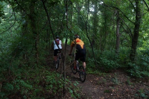
On the trails at Gunn Park
Halsey: I actually started building in the fall of 2009 without much planning or even permission. The city made me stop for all of 2010 while they did their due diligence.
During this time I worked on maintaining the original mile loop, and scoped out other areas of timber in the park. In the spring of 2011 the city granted permission to proceed, and a few great volunteers got involved.
We built about 2 ½ miles during the spring and summer of 2011, and then another mile or so in the spring of 2012. Because of ongoing maintenance, there really hasn’t been much opportunity to build the additional two miles that we have planned.
Kansas Trail Guide: Do you have a favorite part of the trail?
Halsey: I actually have a couple favorite sections of trail. The “North Ridge Ride” was our first attempt at building on the side of a hill. It’s downhill and only slightly tricky, but fun. The “River Ride” is cool because it runs right next to the river and has some fun rolling runs, and finally the “West River Ridge” because we initially didn’t think it could be done.
Kansas Trail Guide: What are some factors about trail building and maintenance that people should realize?
Halsey: I love it, but it’s a big commitment! Much more than I ever imagined. My wife (she’s an angel) is really the only person that truly understands how much time I spend on the trails. Gunn Park is practically in my back yard, so for me it’s close by, relaxing, therapeutic, most of the time spontaneous, so I tend to lose track of how long I’m down there. Probably like gardening for somebody that likes gardening. I spend a lot of time, by myself, maintaining and improving what we have. Kind of like weeding a big garden.
We had a tremendous group of volunteers help build the trails initially. Sadly, volunteers wear out after a while, and they don’t share the same passion. We try to have regular work sessions but only a couple of us show up. I get that, many of them still have kids activities, and other hobbies, I don’t. This has become my hobby. My golf game is suffering, but that’s OK, this is better for me.
A lot of people think I’m just plain nuts, but what they fail to realize is the sanity I gain from the simply being out in the woods and creating something. I get a lot more credit than I deserve, because really I’m selfishly doing this for me. That others can take advantage is just a bonus. However, whenever I see anybody else on the trails, riding, jogging or hiking, it gives me a tremendous feeling of satisfaction.
Probably what I would caution others about is the “volunteers wear out” part. The city does not have the resources to maintain what we’ve built and likely never will. I have a couple of guys I can expect to show up 50% of the time. Other than that, people have other commitments. So, if planning to build trails, be careful what you ask for, you might get it. Also, if building next to a river that floods occasionally, be prepared for lots of cleanup time.


 I was accompanied by the venerable patriarch of the family; official photographer, reliable shuttle driver, and all around great trail companion.


